
Photo Record
Images
Additional Images [2]
Metadata
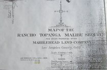
Title |
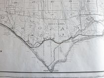
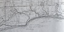
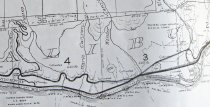
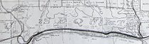
Rancho Malibu 1931 Marblehead Land Co. map |
Catalog Number |
RMb-50.1 |
Object Name |
Print, Photographic |
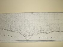
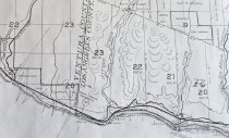
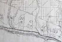
Description |
1931/1924 map of Rancho Malibu, commissioned by the Marblehead Land Co (MBL), a Rindge land holding company formed by May Rindge in 1921, mostly to oversee the numerous and complex land holdings created by Frederick Rindge before his death. The original reason for commissioning this map in 1924 is unclear, but was probably simply for documentation of the Rindge Malibu land holdings. It shows the original, short-lived 1923 County dirt road, the first road to open the Rancho to the public, and the State paved highway (Roosevelt Highway), completed between 1926-1929. It aso shows the pathway of the Rindge railway under the name Hueneme, Malibu and Southern Rwy. Finally, it shows the homesteader land grants surrounding the Rancho. This very valuable map shows the Rancho as it was transitioning from a private ranch to the City of Malibu of today. The map segments shown are overlapping segments proceeding from the western (Yerba Buena Canyon) to the eastern (Las Flores Canyon) boundaries of the Rancho. |
Photographer |
n/a |
Copyright |
MBL |
Search Terms |
Rancho Malibu 1931 map Rindge railway Roosevelt HIghway County dirt road Rancho Malibu |
Status |
Restricted |